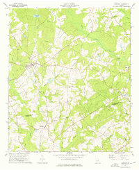
1973 Map of Harrison
USGS Topo · Published 1976About this map
Harrison serves as a central point of activity on this mid-1970s survey, situated along the Central of Georgia railroad line. The surrounding landscape of Washington and Johnson counties is defined by a dense network of country roads and timbered creek bottoms. Small rural hubs like Donovan and Pringle anchor the local community, while the Washington-Johnson Sch and various churches such as Beulah Ch and New Bethel Ch reflect the area's social fabric. This period shows a transition from traditional agricultural patterns to more specialized land use, evidenced by the presence of a Golf Course and a Gravel Pit. The map tracks numerous watercourses, including the Ohoopee River and Little Cedar Creek, which were critical to the early development of this region.
Find a feature on this map
45 named features on this map. Tap any name to fly to it.
Don’t see what you’re looking for? This feature index may not catch every label — zoom into the map to look around manually.
Map Details
Editions of this 1973 Harrison Map
This is the sole edition of this map. No revisions or reprints were ever made.
Other maps of this area

1957 · Macon
USGS Topo · 1:250,000

1958 · Macon
USGS Topo · 1:250,000

1962 · Irwins Crossroads
USGS Topo · 1:24,000

1962 · Sandersville
USGS Topo · 1:24,000

1964 · Macon
USGS Topo · 1:250,000
1973 · Davisboro SE
USGS Topo · 1:24,000
1973 · Riddleville
USGS Topo · 1:24,000

1974 · Kite
USGS Topo · 1:24,000

1974 · Wrightsville
USGS Topo · 1:24,000

1974 · Lovett
USGS Topo · 1:24,000