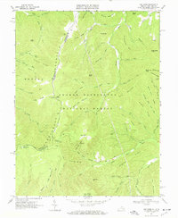
1967 Map of Cow Knob
USGS Topo · Published 1969About this map
Shenandoah Mountain forms the backbone of this high-elevation landscape within the George Washington National Forest, marking the interstate boundary between Rockingham County, Virginia, and Pendleton County, West Virginia. In the late 1960s, this area remained largely defined by its network of watersheds and steep ridges, with a prominent Lookout Tower standing sentinel at Cow Knob. The drainage patterns are intricate, with the Shaver River and Dry River collecting runoff from numerous hollows like Snake Hollow and Clay Lick Hollow. This survey provides a precise record of the mid-century infrastructure used for forest management and backcountry access, including the Bethel Trail and several specialized paths such as the Rader Jeep Trail. Named landmarks like Fulk Mtn, Kretchie Mtn, and Hall Spring offer specific points of reference for those studying the regional geography and land use history of the Alleghany highlands.
Find a feature on this map
64 named features on this map. Tap any name to fly to it.
Don’t see what you’re looking for? This feature index may not catch every label — zoom into the map to look around manually.
Map Details
Editions of this 1967 Cow Knob Map
3 editions found
Other maps of this area

1892 · Franklin
USGS Topo · 1:125,000

1892 · Woodstock
USGS Topo · 1:125,000

1896 · Franklin
USGS Topo · 1:125,000

1920 · Petersburg
USGS Topo · 1:48,000

1921 · Orkney Springs
USGS Topo · 1:48,000

1921 · Petersburg
USGS Topo · 1:48,000

1922 · Fort Seybert
USGS Topo · 1:48,000

1922 · Petersburg
USGS Topo · 1:62,500

1923 · Orkney Springs
USGS Topo · 1:62,500

1924 · Fort Seybert
USGS Topo · 1:62,500