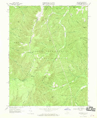
1967 Map of Cow Knob
USGS Topo · Published 1970About this map
Cow Knob stands as a prominent landmark on the high ridgeline where the Pendleton and Rockingham county line meets the state border between West Virginia and Virginia. This mid-century survey captures a landscape dominated by the protected acreage of the George Washington National Forest and the Shenandoah National Forest. A lone Lookout Tower marks the summit of the knob, overlooking a complex system of drainage and narrow ridges.
Find a feature on this map
59 named features on this map. Tap any name to fly to it.
Don’t see what you’re looking for? This feature index may not catch every label — zoom into the map to look around manually.
Map Details
Editions of this 1967 Cow Knob Map
3 editions found
Other maps of this area

1892 · Franklin
USGS Topo · 1:125,000

1892 · Woodstock
USGS Topo · 1:125,000

1896 · Franklin
USGS Topo · 1:125,000

1920 · Petersburg
USGS Topo · 1:48,000

1921 · Orkney Springs
USGS Topo · 1:48,000

1921 · Petersburg
USGS Topo · 1:48,000

1922 · Fort Seybert
USGS Topo · 1:48,000

1922 · Petersburg
USGS Topo · 1:62,500

1923 · Orkney Springs
USGS Topo · 1:62,500

1924 · Fort Seybert
USGS Topo · 1:62,500