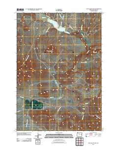
2011 Map of Cow Valley East
USGS Topo · Published 2011About this map
Malheur Reservoir dominates the northern reaches of this high-desert landscape in Malheur County, where the waters of Willow Creek are impounded before flowing eastward. The terrain is defined by its drainage basins and ridges, including the prominent Reservoir Butte and the elevation of Brogan Hill. To the south, Cow Valley provides a level expanse between the rising peaks, serves as a natural corridor for regional travel.
Find a feature on this map
17 named features on this map. Tap any name to fly to it.
Don’t see what you’re looking for? This feature index may not catch every label — zoom into the map to look around manually.
Map Details
Editions of this 2011 Cow Valley East Map
This is the sole edition of this map. No revisions or reprints were ever made.
Other maps of this area

1955 · Baker
USGS Topo · 1:250,000

1959 · Baker
USGS Topo · 1:250,000

1964 · Bridgeport
USGS Topo · 1:62,500

1964 · Brogan
USGS Topo · 1:62,500

1964 · Ironside
USGS Topo · 1:62,500

1966 · Clover Creek Ranch
USGS Topo · 1:62,500

1980 · Brogan
USGS Topo · 1:100,000
1990 · Mormon Basin
USGS Topo · 1:24,000
1990 · Brady Creek
USGS Topo · 1:24,000
1990 · Scratch Post Butte
USGS Topo · 1:24,000