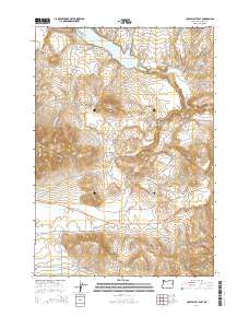
2014 Map of Cow Valley East
USGS Topo · Published 2014About this map
Malheur Reservoir dominates the northern landscape of this Malheur County high-desert terrain, where drainage networks like Cottonwood Cr and Willow Cr carve through the arid plateau. The map centers on the transition between the rolling uplands of Reservoir Butte and the namesake Cow Valley to the south. Historically significant transit corridors define the layout of the region, most notably the Military Rd and the John Day Hwy, which intersect near the drainage of Antelope Springs Cr. These routes speak to the area's long-standing role as a passage for travel and livestock through the southeastern Oregon interior. The elevation rises significantly at Brogan Hill and Brogan Hill Summit, overlooking a topography defined by complex water management features like Davis Reservoir Four and seasonal creeks.
Find a feature on this map
21 named features on this map. Tap any name to fly to it.
Don’t see what you’re looking for? This feature index may not catch every label — zoom into the map to look around manually.
Map Details
Editions of this 2014 Cow Valley East Map
This is the sole edition of this map. No revisions or reprints were ever made.
Other maps of this area

1955 · Baker
USGS Topo · 1:250,000

1959 · Baker
USGS Topo · 1:250,000

1964 · Bridgeport
USGS Topo · 1:62,500

1964 · Brogan
USGS Topo · 1:62,500

1964 · Ironside
USGS Topo · 1:62,500

1966 · Clover Creek Ranch
USGS Topo · 1:62,500

1980 · Brogan
USGS Topo · 1:100,000
1990 · Mormon Basin
USGS Topo · 1:24,000
1990 · Brady Creek
USGS Topo · 1:24,000
1990 · Scratch Post Butte
USGS Topo · 1:24,000