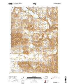
2020 Map of Cow Valley East
USGS Topo · Published 2020About this map
Malheur Reservoir dominates the northern high desert landscape, serving as a primary water source in this corner of Malheur County. The terrain is defined by a series of volcanic features and drainage networks, with Reservoir Butte standing prominently south of the reservoir and Cow Valley Butte marking the western hills. The southern reaches of the map reveal the expanse of Cow Valley, a geographic depression overlooked by Brogan Hill and its highest point at Brogan Hill Summit.
Find a feature on this map
20 named features on this map. Tap any name to fly to it.
Don’t see what you’re looking for? This feature index may not catch every label — zoom into the map to look around manually.
Map Details
Editions of this 2020 Cow Valley East Map
This is the sole edition of this map. No revisions or reprints were ever made.
Other maps of this area

1955 · Baker
USGS Topo · 1:250,000

1959 · Baker
USGS Topo · 1:250,000

1964 · Bridgeport
USGS Topo · 1:62,500

1964 · Brogan
USGS Topo · 1:62,500

1964 · Ironside
USGS Topo · 1:62,500

1966 · Clover Creek Ranch
USGS Topo · 1:62,500

1980 · Brogan
USGS Topo · 1:100,000
1990 · Mormon Basin
USGS Topo · 1:24,000
1990 · Brady Creek
USGS Topo · 1:24,000
1990 · Scratch Post Butte
USGS Topo · 1:24,000