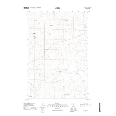
2020 Map of Cox Butte
USGS Topo · Published 2020About this map
Cox Butte rises above a landscape defined by an intricate network of drainage channels and prominent elevations in this Garfield County interior. The terrain is marked by a series of named coulees, including Sand Coulee, Tuccori Coulee, and Deeks Coulee, which direct seasonal runoff toward S Fork Lodgepole Cr and the Dry Fork Calf Cr. These drainage patterns are interspersed with distinct geologic features such as Waddington Dome and several family-named buttes like Thomas Butte and Neiter Butte. Settlement here is sparse, with infrastructure limited to the Sand Springs Strip and Benzien Rd, reflecting the ranching and livestock history of this part of Montana. The map provides a clear look at the public land survey system, illustrating the townships and sections that organize this remote territory.
Find a feature on this map
24 named features on this map. Tap any name to fly to it.
Don’t see what you’re looking for? This feature index may not catch every label — zoom into the map to look around manually.
Map Details
Editions of this 2020 Cox Butte Map
This is the sole edition of this map. No revisions or reprints were ever made.
Other maps of this area

1954 · Jordan
USGS Topo · 1:250,000

1954 · Forsyth
USGS Topo · 1:250,000

1956 · Jordan
USGS Topo · 1:250,000

1957 · Forsyth
USGS Topo · 1:250,000

1958 · Jordan
USGS Topo · 1:250,000

1958 · Forsyth
USGS Topo · 1:250,000

1963 · Mc Williams Springs
USGS Topo · 1:24,000
1963 · Dutton Ranch
USGS Topo · 1:24,000

1964 · Jordan
USGS Topo · 1:250,000
1965 · Sand Springs
USGS Topo · 1:24,000