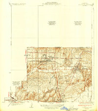
1935 Map of Coyote Hills
USGS Topo · Published 1935About this map
La Habra and Brea serve as the primary hubs in this mid-1930s landscape, which is defined by a transition from industrial activity to agricultural and residential settlement. The influence of petroleum production is clear in the east, centered around a large Tank Farm near the hills, while the agricultural roots of the area are represented by the sprawling Bastianchury Ranch. The region's social structure is visible through its educational landmarks, including the Mexican Sch and the Brea Olinda Union High Sch.
Find a feature on this map
30 named features on this map. Tap any name to fly to it.
Don’t see what you’re looking for? This feature index may not catch every label — zoom into the map to look around manually.
Map Details
Editions of this 1935 Coyote Hills Map
2 editions found
Other maps of this area

1894 · Los Angeles
USGS Topo · 1:62,500

1894 · Pomona
USGS Topo · 1:62,500

1896 · Pasadena
USGS Topo · 1:62,500

1896 · Anaheim
USGS Topo · 1:62,500

1896 · Downey
USGS Topo · 1:62,500

1897 · Pomona
USGS Topo · 1:62,500

1898 · Pomona
USGS Topo · 1:62,500

1898 · Anaheim
USGS Topo · 1:62,500

1899 · Downey
USGS Topo · 1:62,500

1900 · Pasadena
USGS Topo · 1:62,500