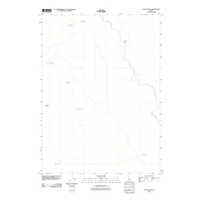
2010 Map of Coyote Hole
USGS Topo · Published 2010About this map
The South Fork Owyhee River snakes through a high desert landscape dominated by drainage catchments and grazing resources in Owyhee County. This remote corner of Idaho is characterized by a series of man-made and seasonal water features critical to the region's ranching operations. The terrain centers on Coyote Hole and the Walcot Basin, with numerous livestock reservoirs scattered across the flats. Named landmarks like John G Reservoir, Upper John G Reservoir, and Bull Camp Reservoir suggest a history of family-led land use and water management in a semi-arid environment. The presence of Last Chance Reservoir and Breakdown Reservoir hints at the challenges of maintaining reliable water sources in this isolated rangeland.
Find a feature on this map
10 named features on this map. Tap any name to fly to it.
Don’t see what you’re looking for? This feature index may not catch every label — zoom into the map to look around manually.
Map Details
Editions of this 2010 Coyote Hole Map
This is the sole edition of this map. No revisions or reprints were ever made.
Other maps of this area

1955 · McDermitt
USGS Topo · 1:250,000

1955 · Jordan Valley
USGS Topo · 1:250,000

1957 · Jordan Valley
USGS Topo · 1:250,000

1958 · Jordan Valley
USGS Topo · 1:250,000

1959 · McDermitt
USGS Topo · 1:250,000

1973 · Coyote Hole
USGS Topo · 1:24,000
1973 · Piute Basin West
USGS Topo · 1:24,000

1973 · Grassy Ridge
USGS Topo · 1:24,000

1973 · Spring Creek Basin
USGS Topo · 1:24,000

1973 · Bull Camp Butte
USGS Topo · 1:24,000