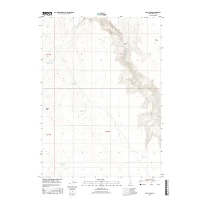
2017 Map of Coyote Hole
USGS Topo · Published 2017About this map
The South Fork Owyhee River cuts a deep, winding path through the high desert of Owyhee County, defining the eastern half of this remote Idaho landscape. The terrain is characterized by a high plateau that drops sharply into the river canyon, where the namesake Coyote Hole is situated. Water management is the primary evidence of human activity in this arid environment, represented by a network of small, scattered catchments including Bull Camp Reservoir, Last Chance Reservoir, and Stump Reservoir. These features, along with the Y P Desert, illustrate the challenges of ranching and resource management in the Great Basin. To the west, the Walcot Basin and Upper Walcot Basin Reservoir suggest a reliance on seasonal runoff to sustain livestock in an area otherwise devoid of permanent settlements.
Find a feature on this map
15 named features on this map. Tap any name to fly to it.
Don’t see what you’re looking for? This feature index may not catch every label — zoom into the map to look around manually.
Map Details
Editions of this 2017 Coyote Hole Map
This is the sole edition of this map. No revisions or reprints were ever made.
Other maps of this area

1955 · McDermitt
USGS Topo · 1:250,000

1955 · Jordan Valley
USGS Topo · 1:250,000

1957 · Jordan Valley
USGS Topo · 1:250,000

1958 · Jordan Valley
USGS Topo · 1:250,000

1959 · McDermitt
USGS Topo · 1:250,000

1973 · Coyote Hole
USGS Topo · 1:24,000
1973 · Piute Basin West
USGS Topo · 1:24,000

1973 · Grassy Ridge
USGS Topo · 1:24,000

1973 · Spring Creek Basin
USGS Topo · 1:24,000

1973 · Bull Camp Butte
USGS Topo · 1:24,000