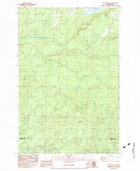
1983 Map of Coyote Mtn
USGS Topo · Published 1983About this map
The high ridges of Coyote Mountain and Crazy Man Mountain dominate this corner of the Cascade foothills in the early 1980s. This transitional landscape, situated on the border of Lewis and Cowlitz counties, reflects the changing uses of the Pacific Northwest forest. The northern edge is defined by the waters of Riffe Lake, with a dashed line indicating a maximum pool elevation subject to inundation at 779 feet.
Find a feature on this map
16 named features on this map. Tap any name to fly to it.
Don’t see what you’re looking for? This feature index may not catch every label — zoom into the map to look around manually.
Map Details
Editions of this 1983 Coyote Mtn Map
2 editions found
Other maps of this area

1916 · Chehalis
USGS Topo · 1:125,000

1919 · Mount St Helens
USGS Topo · 1:125,000

1937 · Eatonville
USGS Topo · 1:125,000

1942 · Toutle
USGS Topo · 1:62,500

1943 · Willapa
USGS Topo · 1:62,500

1953 · Hoquiam
USGS Topo · 1:250,000

1953 · Toutle
USGS Topo · 1:62,500

1953 · Elk Rock
USGS Topo · 1:62,500

1954 · Onalaska
USGS Topo · 1:62,500

1957 · Hoquiam
USGS Topo · 1:250,000