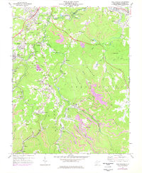
1968 Map of Crab Orchard
USGS Topo · Published 1977About this map
The rugged coal-country landscape of Raleigh County is defined by the steep ridges of Guyandotte Mountain and Shady Spring Mountain in the late 1960s. The region is a dense network of industrial development, where strip mines, mine dumps, and a tipple at Whitby illustrate the intense extraction occurring alongside residential communities. Transport for these operations is provided by the Norfolk and Western and Chesapeake and Ohio railroads, which wind through the narrow valleys following Piney Creek and Soak Creek. Local life centers around a string of settlements like Coal City, Lillybrook, and Sophia, with social landmarks including the Friendly Ch and Stoco High Sch. Modern infrastructure also marks the terrain, notably the West Virginia Turnpike and the Toll Road cutting through the northern hills near Fitzpatrick Park.
Find a feature on this map
67 named features on this map. Tap any name to fly to it.
Don’t see what you’re looking for? This feature index may not catch every label — zoom into the map to look around manually.
Map Details
Editions of this 1968 Crab Orchard Map
2 editions found
Other maps of this area

1891 · Raleigh
USGS Topo · 1:125,000

1897 · Raleigh
USGS Topo · 1:125,000

1902 · Raleigh
USGS Topo · 1:125,000

1911 · Marshes
USGS Topo · 1:48,000

1911 · Flattop
USGS Topo · 1:48,000

1911 · Beckley
USGS Topo · 1:48,000

1912 · Mullens
USGS Topo · 1:62,500

1913 · Beckley
USGS Topo · 1:62,500

1914 · Eccles
USGS Topo · 1:62,500

1914 · Flattop
USGS Topo · 1:62,500