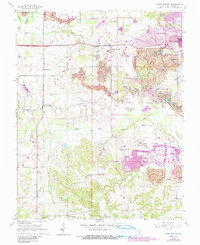
1990 Map of Crab Orchard
USGS Topo · Published 1990About this map
Extensive surface mining operations dominate the landscape east of Crab Orchard and north of the South Fork Saline River, where the reclaimed strip mine areas are indicated by distinct purple tinting. This revision reveals a rural Williamson County geography in transition, where legacy landmarks like the Barbara Kay Mine and an air shaft near the eastern border sit amidst an older network of family cemeteries and country churches. Historically significant sites such as the Old Krieger Cem and Moore Cem are preserved alongside the Illinois Central Railroad grade.
Find a feature on this map
39 named features on this map. Tap any name to fly to it.
Don’t see what you’re looking for? This feature index may not catch every label — zoom into the map to look around manually.
Map Details
Editions of this 1990 Crab Orchard Map
This is the sole edition of this map. No revisions or reprints were ever made.
Other maps of this area

1908 · Galatia
USGS Topo · 1:62,500

1909 · West Frankfort
USGS Topo · 1:62,500

1925 · Marion
USGS Topo · 1:62,500

1925 · Harrisburg
USGS Topo · 1:62,500

1938 · Galatia
USGS Topo · 1:62,500

1939 · Harrisburg
USGS Topo · 1:62,500

1940 · Marion
USGS Topo · 1:62,500

1941 · West Frankfort
USGS Topo · 1:62,500

1949 · Paducah
USGS Topo · 1:250,000

1950 · Paducah
USGS Topo · 1:250,000