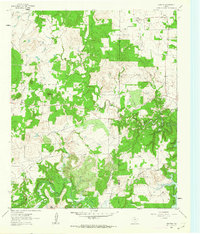
1961 Map of Crafton
USGS Topo · Published 1963About this map
The Jack Co Wise Co line bisects this 1961 rural landscape, where the northern waters of Lake Bridgeport meet the winding course of the West Fork Trinity River. The settlement of Crafton serves as a small hub in the northeast corner, while Cundiff sits to the west along a straight roadway that cuts through the rolling terrain. This area, largely defined by ranching and oil exploration, is marked by numerous scattered Oil Wells and a dense network of drainage creeks, including Big Cottonwood Creek and Big Sandy Creek. For local historians and genealogists, the map preserves specific points of interest such as the Thomas Norwood Cem and the prominent elevation of Bear Knob, alongside several unnamed Cem locations that provide a record of early community life before later development.
Find a feature on this map
17 named features on this map. Tap any name to fly to it.
Don’t see what you’re looking for? This feature index may not catch every label — zoom into the map to look around manually.
Map Details
Editions of this 1961 Crafton Map
2 editions found
Other maps of this area

1954 · Sherman
USGS Topo · 1:250,000

1954 · Wichita Falls
USGS Topo · 1:250,000

1958 · Wichita Falls
USGS Topo · 1:250,000

1958 · Sherman
USGS Topo · 1:250,000

1960 · Bridgeport West
USGS Topo · 1:24,000

1960 · Wizard Wells
USGS Topo · 1:24,000

1961 · Selma
USGS Topo · 1:24,000

1961 · Jacksboro NE
USGS Topo · 1:24,000

1961 · Sunset
USGS Topo · 1:24,000

1961 · Crafton
USGS Topo · 1:24,000