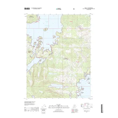
2017 Map of Craig A-1 NE
USGS Topo · Published 2017About this map
The Tongass National Forest dominates this coastal Alaskan landscape, where the intricate shoreline of Prince of Wales Island meets the Pacific Ocean. This 2017 survey details a wilderness defined by deep-water inlets and rugged elevations, notably Dolomite Mtn which stands between James Lake and the waters of Dolomite Bay. The map documents a sparse human footprint, centered primarily on the Airport Road Kitkun Bay corridor and the protected waters of Port Johnson.
Find a feature on this map
28 named features on this map. Tap any name to fly to it.
Don’t see what you’re looking for? This feature index may not catch every label — zoom into the map to look around manually.
Map Details
Editions of this 2017 Craig A-1 NE Map
This is the sole edition of this map. No revisions or reprints were ever made.
Other maps of this area

1948 · Ketchikan A-6
USGS Topo · 1:63,360

1948 · Craig A-1
USGS Topo · 1:63,360

1949 · Craig B-1
USGS Topo · 1:63,360

1950 · Craig B-1
USGS Topo · 1:63,360

1952 · Ketchikan
USGS Topo · 1:250,000

1953 · Ketchikan B-6
USGS Topo · 1:63,360

1954 · Ketchikan B-6
USGS Topo · 1:63,360

1955 · Ketchikan
USGS Topo · 1:250,000

1957 · Craig
USGS Topo · 1:250,000
1994 · Ketchikan B-6
USGS Topo · 1:63,360