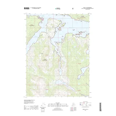
2017 Map of Craig A-1 NW
USGS Topo · Published 2017About this map
Tongass National Forest dominates the landscape of this Prince of Wales Island quadrangle, where the temperate rainforest meets the intricate waterways of the Alexander Archipelago. The deep inlet of Dora Bay carves into the terrain, nearly meeting the South Arm Cholmondeley Sound at a narrow land bridge near Divide Head. This coastal network was vital for regional transport and local industry, as evidenced by the presence of Airport Road Kitkun Bay connecting the eastern shoreline toward the interior. Further inland, freshwater features like Dora Lake and Miller Lake sit in the shadows of high ridges, while the northern coastline is punctuated by sheltered spots such as Sunny Cove and Sunny Point. The map illustrates a region where maritime access remains the primary driver of human movement and resource management within the forest boundaries.
Find a feature on this map
20 named features on this map. Tap any name to fly to it.
Don’t see what you’re looking for? This feature index may not catch every label — zoom into the map to look around manually.
Map Details
Editions of this 2017 Craig A-1 NW Map
This is the sole edition of this map. No revisions or reprints were ever made.
Other maps of this area

1948 · Craig A-1
USGS Topo · 1:63,360

1948 · Craig A-2
USGS Topo · 1:63,360

1949 · Craig B-2
USGS Topo · 1:63,360

1949 · Craig B-1
USGS Topo · 1:63,360

1950 · Craig B-1
USGS Topo · 1:63,360

1951 · Craig B-2
USGS Topo · 1:63,360

1951 · Craig A-2
USGS Topo · 1:63,360

1957 · Craig
USGS Topo · 1:250,000
1996 · Craig A-2
USGS Topo · 1:63,360
1997 · Craig A-1
USGS Topo · 1:63,360