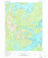
1948 Map of Craig A-1
USGS Topo · Published 1971About this map
Prince of Wales Island is deeply incised by the complex waterways of Cholmondeley Sound and Moira Sound in this late 1940s topographical record. The industrial footprint of the era is evident at the Dolomi (Abandoned) site and the Cannery at Cannery Cove, indicating the historic importance of the region’s timber and fishing economies. The landscape is defined by steep coastal elevations like Eudora Mountain and Dolomi Mtn, which separate sheltered interior waters such as Kitkun Bay and the North Arm from the open sea.
Find a feature on this map
53 named features on this map. Tap any name to fly to it.
Don’t see what you’re looking for? This feature index may not catch every label — zoom into the map to look around manually.
Map Details
Editions of this 1948 Craig A-1 Map
4 editions found
Other maps of this area

1948 · Dixon Entrance D-2
USGS Topo · 1:63,360

1948 · Prince Rupert D-6
USGS Topo · 1:63,360

1948 · Ketchikan A-6
USGS Topo · 1:63,360

1948 · Craig A-1
USGS Topo · 1:63,360

1948 · Dixon Entrance D-1
USGS Topo · 1:63,360

1948 · Craig A-2
USGS Topo · 1:63,360

1949 · Craig B-2
USGS Topo · 1:63,360

1949 · Craig B-1
USGS Topo · 1:63,360

1950 · Craig B-1
USGS Topo · 1:63,360

1951 · Craig B-2
USGS Topo · 1:63,360