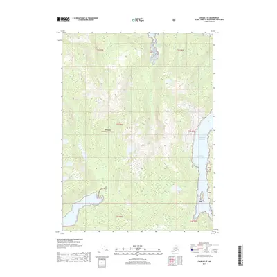
2017 Map of Craig A-2 NE
USGS Topo · Published 2017About this map
Tongass National Forest encompasses the entirety of this coastal Alaska landscape, characterized by complex waterways and significant elevation changes. The shoreline is defined by the deep indentations of the West Arm Cholmondeley Sound and the South Arm Cholmondeley Sound, which penetrate deep into the landmass from the Pacific Ocean. This 2017 survey illustrates a wilderness area largely devoid of modern road infrastructure, where the terrain rises sharply from the sea into high ridges. Inland, drainage is managed by systems like Big Cr, which flows northward into the sound. The map provides a precise look at the township and range divisions within this protected forest, including sections of t77s r86e and t77s r87e, capturing the intersection of maritime geography and federal land management in the Unorganized Borough.
Find a feature on this map
12 named features on this map. Tap any name to fly to it.
Don’t see what you’re looking for? This feature index may not catch every label — zoom into the map to look around manually.
Map Details
Editions of this 2017 Craig A-2 NE Map
This is the sole edition of this map. No revisions or reprints were ever made.
Other maps of this area

1948 · Craig A-1
USGS Topo · 1:63,360

1948 · Craig A-2
USGS Topo · 1:63,360

1949 · Craig B-2
USGS Topo · 1:63,360

1949 · Craig B-1
USGS Topo · 1:63,360

1950 · Craig B-1
USGS Topo · 1:63,360

1951 · Craig B-2
USGS Topo · 1:63,360

1951 · Craig A-2
USGS Topo · 1:63,360

1957 · Craig
USGS Topo · 1:250,000
1996 · Craig A-2
USGS Topo · 1:63,360
1997 · Craig A-1
USGS Topo · 1:63,360