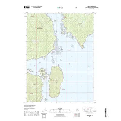
2017 Map of Craig B-5 NE
USGS Topo · Published 2017About this map
Tongass National Forest encompasses the entirety of this coastal landscape within the Alexander Archipelago, where a labyrinth of waterways separates numerous named islands and landforms. The region's maritime character is defined by the Portillo Channel and Ursua Channel, which wrap around a cluster of landmasses including San Fernando Island and Saint Ignace Island. Along the western shoreline, Port Real Marina serves as a sheltered point of interest near Triste Island and Muerta Island. The map records a variety of Spanish-named features such as Point Caponeta, Arrecife Point, and Point Amargura, reflecting the exploratory history of these southeastern Alaskan waters. The complex shoreline includes numerous small features like Sucia Ledge, Rana Reef, and the Arrecife Islands, illustrating the navigational challenges of the coastal terrain.
Find a feature on this map
45 named features on this map. Tap any name to fly to it.
Don’t see what you’re looking for? This feature index may not catch every label — zoom into the map to look around manually.
Map Details
Editions of this 2017 Craig B-5 NE Map
This is the sole edition of this map. No revisions or reprints were ever made.
Other maps of this area

1948 · Craig B-5
USGS Topo · 1:63,360

1949 · Craig C-4
USGS Topo · 1:63,360

1949 · Craig B-4
USGS Topo · 1:63,360

1951 · Craig B-4
USGS Topo · 1:63,360

1951 · Craig C-4
USGS Topo · 1:63,360

1951 · Craig C-5
USGS Topo · 1:63,360

1957 · Craig
USGS Topo · 1:250,000

2000 · Craig B-5
USGS Topo · 1:63,360
2017 · Craig B-4 SW
USGS Topo · 1:25,000
2017 · Craig C-5 SW
USGS Topo · 1:25,000