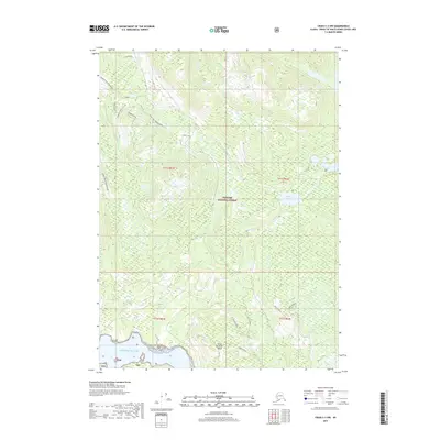
2017 Map of Craig C-3 NW
USGS Topo · Published 2017About this map
Prince of Wales Island is the centerpiece of this coastal survey, where the temperate rainforest of the Tongass National Forest meets the northern reaches of the Pacific Ocean. The landscape is defined by a complex network of timber and access roads, including the descriptively named Ten By Ten 2050020 Road and the Saddle Spur 2050050 Road, which snake through the drainage basins of Staney Cr. High alpine features like Shaheen and the clearings of Camp Meadow provide contrast to the dense drainage systems feeding into Control Lake and Toms Lake. The interior's steep relief is punctuated by landmarks such as Wolf Pass Falls and the Cutthroat Lakes, illustrating the freshwater systems that sustain this environment. This map captures the mid-2010s state of forest management infrastructure in an area where land-use boundaries like t71s r81e intersect with rugged natural terrain.
Find a feature on this map
24 named features on this map. Tap any name to fly to it.
Don’t see what you’re looking for? This feature index may not catch every label — zoom into the map to look around manually.
Map Details
Editions of this 2017 Craig C-3 NW Map
This is the sole edition of this map. No revisions or reprints were ever made.
Other maps of this area

1949 · Craig D-3
USGS Topo · 1:63,360

1949 · Craig D-4
USGS Topo · 1:63,360

1949 · Craig C-3
USGS Topo · 1:63,360

1949 · Craig C-4
USGS Topo · 1:63,360

1950 · Craig D-3
USGS Topo · 1:63,360

1951 · Craig C-3
USGS Topo · 1:63,360

1951 · Craig C-4
USGS Topo · 1:63,360

1951 · Craig D-4
USGS Topo · 1:63,360

1957 · Craig
USGS Topo · 1:250,000
1994 · Craig D-3
USGS Topo · 1:63,360