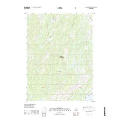
2017 Map of Craig C-4 NE
USGS Topo · Published 2017About this map
The Alexander Archipelago landscape dominates this portion of the Tongass National Forest, characterized by the prominent elevation of Staney Cone. The interior terrain is defined by a dense network of forest service access points, including Twin Spur, Saddle Spur, and Spring Spur One, which trace the drainage basins of Staney Cr and Shaheen Cr. These arterial routes, such as the 2050332 Road and Plateau Spur 2050060 Road, reflect the intensive forest management and logging infrastructure vital to the region's economy. The interplay of high ridges and narrow creek valleys like Woodsy Creek illustrates the complex topography of Prince of Wales Island during the early 21st century.
Find a feature on this map
23 named features on this map. Tap any name to fly to it.
Don’t see what you’re looking for? This feature index may not catch every label — zoom into the map to look around manually.
Map Details
Editions of this 2017 Craig C-4 NE Map
This is the sole edition of this map. No revisions or reprints were ever made.
Other maps of this area

1949 · Craig D-3
USGS Topo · 1:63,360

1949 · Craig D-4
USGS Topo · 1:63,360

1949 · Craig C-3
USGS Topo · 1:63,360

1949 · Craig C-4
USGS Topo · 1:63,360

1950 · Craig D-3
USGS Topo · 1:63,360

1951 · Craig C-3
USGS Topo · 1:63,360

1951 · Craig C-4
USGS Topo · 1:63,360

1951 · Craig D-4
USGS Topo · 1:63,360

1957 · Craig
USGS Topo · 1:250,000
1994 · Craig D-3
USGS Topo · 1:63,360