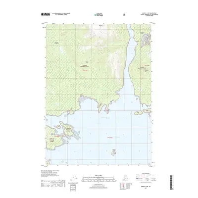
2017 Map of Craig D-1 NW
USGS Topo · Published 2017About this map
Etolin Island dominates this coastal landscape within the Tongass National Forest, characterized by the intricate shorelines of the Alexander Archipelago. The terrain rises sharply from the Pacific Ocean to the heights of Mt Shakes, while to the east, the narrow waters of Canoe Passage separate the main landmass from Brownson Island, which is capped by Brownson Peak. This coastal environment is defined by its numerous small archipelagos and outcrops, including the Stone Islands and the Petersen Islands. The map illustrates a maritime-dominated geography where the mountains meet the Gulf of Alaska, showing a wilderness area almost entirely devoid of human-named infrastructure, focusing instead on the complex natural navigation and topography of these Alaskan islands.
Find a feature on this map
16 named features on this map. Tap any name to fly to it.
Don’t see what you’re looking for? This feature index may not catch every label — zoom into the map to look around manually.
Map Details
Editions of this 2017 Craig D-1 NW Map
This is the sole edition of this map. No revisions or reprints were ever made.
Other maps of this area

1948 · Petersburg A-1
USGS Topo · 1:63,360

1948 · Petersburg A-2
USGS Topo · 1:63,360

1949 · Craig D-2
USGS Topo · 1:63,360

1949 · Craig D-1
USGS Topo · 1:63,360

1951 · Craig D-2
USGS Topo · 1:63,360

1951 · Craig D-1
USGS Topo · 1:63,360

1951 · Petersburg A-1
USGS Topo · 1:63,360

1952 · Petersburg
USGS Topo · 1:250,000

1953 · Petersburg A-2
USGS Topo · 1:63,360

1957 · Craig
USGS Topo · 1:250,000