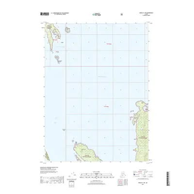
2017 Map of Craig D-1 SW
USGS Topo · Published 2017About this map
Tongass National Forest dominates this coastal survey, which documents the intricate maritime geography of the Alexander Archipelago. The map reveals a landscape defined by isolated landforms and navigational hazards, from the southern reaches of Eagle Island and the Muffin Islands in the north to the treacherous McHenry Ledge and Lemly Rocks that break the waters of the Clarence Strait. The rugged coastlines of the islands are dotted with significant topographical markers such as Onslow Point and Magnetic Point, reflecting the maritime importance of this region. Inland, the map traces small watercourses like Cannery Creek as they drain into Union Bay, illustrating the connection between the forested interior and the surrounding Gulf of Alaska. This 2017 edition provides an exact record of shoreline positions and designated forest lands prior to further environmental or jurisdictional shifts in Southeast Alaska.
Find a feature on this map
21 named features on this map. Tap any name to fly to it.
Don’t see what you’re looking for? This feature index may not catch every label — zoom into the map to look around manually.
Map Details
Editions of this 2017 Craig D-1 SW Map
This is the sole edition of this map. No revisions or reprints were ever made.
Other maps of this area

1949 · Craig C-2
USGS Topo · 1:63,360

1949 · Craig D-2
USGS Topo · 1:63,360

1949 · Craig D-1
USGS Topo · 1:63,360

1950 · Craig C-1
USGS Topo · 1:63,360

1951 · Craig D-2
USGS Topo · 1:63,360

1951 · Craig C-2
USGS Topo · 1:63,360

1951 · Craig C-1
USGS Topo · 1:63,360

1951 · Craig D-1
USGS Topo · 1:63,360

1957 · Craig
USGS Topo · 1:250,000
1994 · Craig C-2
USGS Topo · 1:63,360