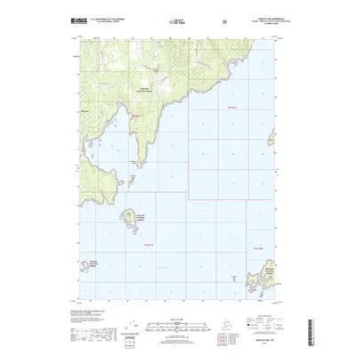
2017 Map of Craig D-5 NW
USGS Topo · Published 2017About this map
Kosciusko Island dominates this coastal landscape, where the settlement of Edna Bay serves as a remote outpost in the Tongass National Forest. The map documents a maritime-dependent environment defined by intricate shorelines and protected waters such as Davidson Inlet and Van Sant Cove. Inland, the topography rises sharply toward Three Knobs, supported by a network of forest roads including the Edna Bay Bypass and Three Knobs 1525200 Road, which likely serve local timber or administrative access. The coastal waters are dotted with numerous small landforms such as Entrance Island, Eagle Island, and Green Island, while Limestone Point and Fox Rock mark significant navigational landmarks for those traversing these Southeast Alaska channels.
Find a feature on this map
23 named features on this map. Tap any name to fly to it.
Don’t see what you’re looking for? This feature index may not catch every label — zoom into the map to look around manually.
Map Details
Editions of this 2017 Craig D-5 NW Map
This is the sole edition of this map. No revisions or reprints were ever made.
Other maps of this area

1948 · Petersburg A-6
USGS Topo · 1:63,360

1949 · Petersburg A-5
USGS Topo · 1:63,360

1951 · Craig D-6
USGS Topo · 1:63,360

1951 · Craig D-5
USGS Topo · 1:63,360

1951 · Petersburg A-6
USGS Topo · 1:63,360

1952 · Petersburg
USGS Topo · 1:250,000

1953 · Petersburg A-5
USGS Topo · 1:63,360

1957 · Craig
USGS Topo · 1:250,000

1960 · Petersburg
USGS Topo · 1:250,000
1995 · Petersburg A-5
USGS Topo · 1:63,360