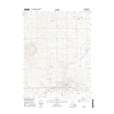
2016 Map of Craig
USGS Topo · Published 2016About this map
The town of Craig sits at the intersection of high-desert terrain and river-valley agriculture, anchored by its proximity to the Yampa River. The landscape is defined by its drainage systems, including Fortification Cr and numerous gulches like Coon Gulch and Big Gulch that cut through the north-central uplands. Agricultural and industrial infrastructure is evident through the presence of the Wisconsin Ditch, Craig Ditch, and a significant powerline corridor to the east. Landforms such as Cedar Mtn and Pine Ridge Gulch provide distinct vertical relief against the expanding street grid of the city. Notable for local history and genealogy, the Craig Cem is clearly marked on the eastern edge of the settlement near Ashley Rd, while the Coyote Reservoir sits as a lonely water source in the western rangelands. The map reveals the intricate network of county roads, such as Co RD 22, that link the remote northern ridges back to the valley floor.
Find a feature on this map
91 named features on this map. Tap any name to fly to it.
Don’t see what you’re looking for? This feature index may not catch every label — zoom into the map to look around manually.
Map Details
Editions of this 2016 Craig Map
This is the sole edition of this map. No revisions or reprints were ever made.
Other maps of this area

1910 · Danforth Hills
USGS Topo · 1:125,000

1915 · Monument Butte
USGS Topo · 1:62,500

1916 · Craig
USGS Topo · 1:125,000

1916 · Daton Peak
USGS Topo · 1:62,500

1920 · Daton Peak
USGS Topo · 1:62,500

1923 · Elkhead Creek
USGS Topo · 1:62,500

1924 · Elkhead Creek
USGS Topo · 1:62,500

1954 · Craig
USGS Topo · 1:250,000

1957 · Craig
USGS Topo · 1:250,000

1958 · Craig
USGS Topo · 1:250,000