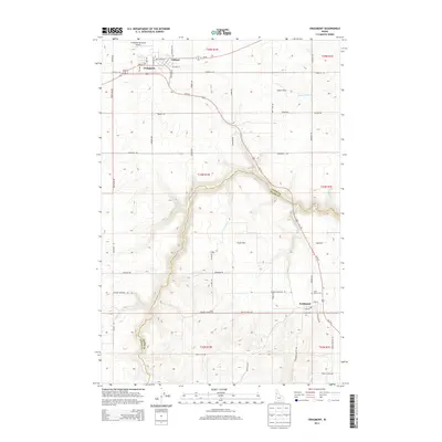
2013 Map of Craigmont
USGS Topo · Published 2013About this map
Craigmont and the adjacent townsite of Vollmer sit atop the Camas Prairie, where the high-elevation wheat country begins its dramatic descent into the deep canyons of the Nez Perce region. This landscape is defined by the sharp transition between the level agricultural lands of Icicle Flat and the steep, winding drainage of Lawyer Cr which carves through the center of the quadrangle. The 2013 survey shows the tight-knit grid of Ferdinand to the southeast, positioned near Saint Maurus Cem and the historical path of the regional rail line along Railroad Ave. A network of section-line roads like Westlake RD and Evergreen RD connects these upland farming communities, while the presence of Dublin Siding and the Craigmont Municipal Airport indicates the area's long-standing role as a transportation and logistics hub for Idaho's interior plateau.
Find a feature on this map
52 named features on this map. Tap any name to fly to it.
Don’t see what you’re looking for? This feature index may not catch every label — zoom into the map to look around manually.
Map Details
Editions of this 2013 Craigmont Map
This is the sole edition of this map. No revisions or reprints were ever made.
Other maps of this area

1924 · Kamiah
USGS Topo · 1:125,000

1955 · Pullman
USGS Topo · 1:250,000

1958 · Pullman
USGS Topo · 1:250,000

1958 · Culdesac
USGS Topo · 1:62,500

1967 · Mohler
USGS Topo · 1:24,000

1967 · Fletcher
USGS Topo · 1:24,000

1967 · Craigmont
USGS Topo · 1:24,000

1967 · Westlake
USGS Topo · 1:24,000
1967 · Keuterville
USGS Topo · 1:24,000

1967 · Cottonwood NE
USGS Topo · 1:24,000