
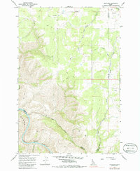
1967 Map of Westlake
USGS Topo · Published 1971About this map
Westlake sits near the shared border of Lewis and Idaho Counties, serving as a high-plateau settlement overlooking a landscape defined by dramatic elevation changes. The southern portion of the area is dominated by the powerful Salmon River, which carves through the terrain to form Long Canyon and the turbulent Snow Hole Rapids. This 1967 field-checked survey highlights a transition from agricultural use to the steep, inaccessible drainage systems of the river canyon.
Find a feature on this map
12 named features on this map. Tap any name to fly to it.
Don’t see what you’re looking for? This feature index may not catch every label — zoom into the map to look around manually.
Map Details
Editions of this 1967 Westlake Map
2 editions found
Other maps of this area

1924 · Kamiah
USGS Topo · 1:125,000

1955 · Pullman
USGS Topo · 1:250,000

1955 · Grangeville
USGS Topo · 1:250,000

1958 · Pullman
USGS Topo · 1:250,000

1959 · Grangeville
USGS Topo · 1:250,000

1963 · Boles
USGS Topo · 1:24,000

1963 · Rattlesnake Ridge
USGS Topo · 1:24,000

1963 · Moughmer Point
USGS Topo · 1:24,000

1967 · Craigmont
USGS Topo · 1:24,000

1967 · Hoover Point
USGS Topo · 1:24,000