
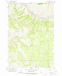
1963 Map of Boles
USGS Topo · Published 1965About this map
Joseph Plains dominates this 1963 survey, where the high plateau landscape of north-central Idaho meets the steep descent into the Salmon River canyon. The settlement of Boles is situated on the eastern edge of the quadrangle, serving as a hub for the scattered homesteads and ranching interests that navigated the network of jeep trails crisscrossing the breaks. This era shows a landscape where remote mountain access was primarily defined by these primitive tracks, linking water sources like Home Sweet Home Creek and Deep Creek to the higher elevations.
Find a feature on this map
26 named features on this map. Tap any name to fly to it.
Don’t see what you’re looking for? This feature index may not catch every label — zoom into the map to look around manually.
Map Details
Editions of this 1963 Boles Map
2 editions found
Other maps of this area

1924 · Kamiah
USGS Topo · 1:125,000

1955 · Pullman
USGS Topo · 1:250,000

1955 · Grangeville
USGS Topo · 1:250,000

1958 · Pullman
USGS Topo · 1:250,000

1959 · Grangeville
USGS Topo · 1:250,000

1963 · Cactus Mtn
USGS Topo · 1:24,000

1963 · Rattlesnake Ridge
USGS Topo · 1:24,000

1963 · Moughmer Point
USGS Topo · 1:24,000

1963 · Joseph
USGS Topo · 1:24,000

1963 · Wolf Creek
USGS Topo · 1:24,000