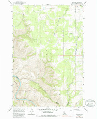
1967 Map of Westlake
USGS Topo · Published 1986About this map
Westlake serves as the primary point of settlement in this northern Idaho landscape, where the high plateau meets the dramatic descent toward the water. The topographical character of the region is defined by the Salmon River carving through the southwest, featuring the Snow Hole Rapids and a distinctive Oxbow near Long Canyon. Remnants of early industrial infrastructure are visible in the form of an Old Railroad Grade that winds through the northern sections, tracing the contours above Willow Creek and Lawyer Creek. This network of Jeep Trails and historic grades suggests a transition from timber or transport-heavy operations to a more isolated rural character by the late 1960s. Drainage patterns are complex, with Maloney Creek and Deep Creek cutting deep into the canyon lands, illustrating the erosion-driven geography of the Lewis County and Idaho County border.
Find a feature on this map
14 named features on this map. Tap any name to fly to it.
Don’t see what you’re looking for? This feature index may not catch every label — zoom into the map to look around manually.
Map Details
Editions of this 1967 Westlake Map
2 editions found

Other maps of this area

1924 · Kamiah
USGS Topo · 1:125,000

1955 · Pullman
USGS Topo · 1:250,000

1955 · Grangeville
USGS Topo · 1:250,000

1958 · Pullman
USGS Topo · 1:250,000

1959 · Grangeville
USGS Topo · 1:250,000

1963 · Boles
USGS Topo · 1:24,000

1963 · Rattlesnake Ridge
USGS Topo · 1:24,000

1963 · Moughmer Point
USGS Topo · 1:24,000

1967 · Craigmont
USGS Topo · 1:24,000

1967 · Hoover Point
USGS Topo · 1:24,000