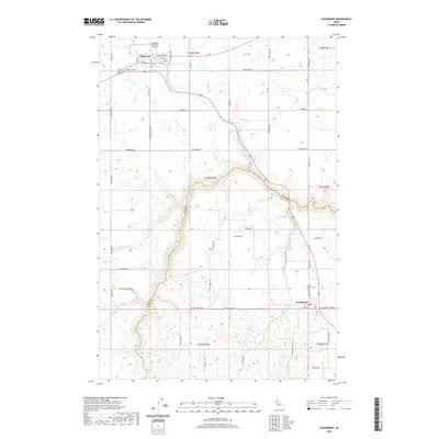
2020 Map of Craigmont
USGS Topo · Published 2020About this map
The high plateau of the Camas Prairie centers on the town of Craigmont, where agricultural lands give way to the dramatic drainage of Lawyer Cr. This landscape is defined by the sharp transition between the level wheat fields of Icicle Flat and the deep, winding canyon system that cuts through the Nez Perce Reservation area. Further south, the small community of Ferdinand sits along the primary transport corridor, historically linked by Old Hwy 95. The map documents a rural infrastructure of family-named roads and remote crossings, such as Holmes Crossing Rd, which provide access to the breaks above the creek. For genealogists and local historians, the placement of Saint Maurus Cem and the Craigmont Municipal Airport offer specific anchors for 21st-century property research and community development patterns.
Find a feature on this map
51 named features on this map. Tap any name to fly to it.
Don’t see what you’re looking for? This feature index may not catch every label — zoom into the map to look around manually.
Map Details
Editions of this 2020 Craigmont Map
This is the sole edition of this map. No revisions or reprints were ever made.
Other maps of this area

1924 · Kamiah
USGS Topo · 1:125,000

1955 · Pullman
USGS Topo · 1:250,000

1958 · Pullman
USGS Topo · 1:250,000

1958 · Culdesac
USGS Topo · 1:62,500

1967 · Mohler
USGS Topo · 1:24,000

1967 · Fletcher
USGS Topo · 1:24,000

1967 · Craigmont
USGS Topo · 1:24,000

1967 · Westlake
USGS Topo · 1:24,000
1967 · Keuterville
USGS Topo · 1:24,000

1967 · Cottonwood NE
USGS Topo · 1:24,000