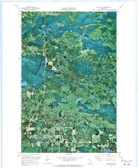
1971 Map of Craigville
USGS Topo · Published 1973About this map
Koochiching State Forest dominates the terrain in this early 1970s orthophotomap, showing a landscape defined by timber resources and heavy winter access. Unlike standard topographic sheets, this orthophoto uses high-altitude imagery from 1969 to reveal the actual texture of the wetlands and forest cover. The tiny settlement of Craigville sits at a bend in the Deer River, which winds aggressively through the southern portion of the quadrangle. Traces of the region's logging and transit history are visible in the Old Railroad Grade and various stretches of Winter Trail, reflecting how isolation was managed in the boggy Northern Minnesota environment. To the southeast, Round Lake provides a notable break in the dense canopy, marking the transition toward the lakes of Itasca County.
Find a feature on this map
8 named features on this map. Tap any name to fly to it.
Don’t see what you’re looking for? This feature index may not catch every label — zoom into the map to look around manually.
Map Details
Editions of this 1971 Craigville Map
This is the sole edition of this map. No revisions or reprints were ever made.
Other maps of this area

1919 · M
USGS Topo · 1:62,500

1954 · Hibbing
USGS Topo · 1:250,000

1954 · International Falls
USGS Topo · 1:250,000

1957 · Hibbing
USGS Topo · 1:250,000

1957 · International Falls
USGS Topo · 1:250,000

1958 · International Falls
USGS Topo · 1:250,000

1958 · Hibbing
USGS Topo · 1:250,000

1964 · Hibbing
USGS Topo · 1:250,000

1970 · Johnson Landing SE
USGS Topo · 1:24,000
1970 · Deer Lake NW
USGS Topo · 1:24,000