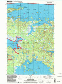
1999 Map of Cranberry Bay
USGS Topo · Published 2003About this map
Voyageurs National Park encompasses the majority of this northern landscape, which straddles the international boundary between Ontario and Minnesota. The area is defined by its complex waterway network, where the expansive Rainy Lake to the north is separated from Kabetogama Lake to the south by a heavily forested peninsula. This map shows the traditional transit routes of the region, including a prominent Portage between Black Bay and the interior, alongside a marked Winter Trail through the timber. Several significant conservation zones intersect here, including the Koochiching State Forest and the Gold Portage State Wildlife Management Area. Notable island landmarks such as Chief Wooden Frogs Islands and Cemetery Island are clearly delineated, illustrating the varied terrain of this borderlands region at the close of the twentieth century.
Find a feature on this map
34 named features on this map. Tap any name to fly to it.
Don’t see what you’re looking for? This feature index may not catch every label — zoom into the map to look around manually.
Map Details
Editions of this 1999 Cranberry Bay Map
This is the sole edition of this map. No revisions or reprints were ever made.
Other maps of this area

1954 · International Falls
USGS Topo · 1:250,000

1957 · International Falls
USGS Topo · 1:250,000

1958 · International Falls
USGS Topo · 1:250,000

1968 · Soldier Point
USGS Topo · 1:24,000

1968 · Daley Bay
USGS Topo · 1:24,000

1969 · Island View
USGS Topo · 1:24,000

1969 · Ray
USGS Topo · 1:24,000

1969 · Cranberry Bay
USGS Topo · 1:24,000

1969 · Kabetogama
USGS Topo · 1:24,000
1978 · International Falls
USGS Topo · 1:100,000