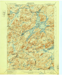
1931 Map of Cranberry Lake
USGS Topo · Published 1931About this map
Cranberry Lake and the winding Oswegatchie River dominate this Adirondack landscape during the interwar years, revealing a region defined by its timber and mining heritage. The map documents the industrial activity at Benson Mines and the settlement of Newton Falls, alongside the educational footprint of the State Ranger School near Wanakena. The irregular shoreline of the lake is punctuated by named points like Barber Point and significant inlets such as Dead Creek Flow and Brandy Brook Flow.
Find a feature on this map
143 named features on this map. Tap any name to fly to it.
Don’t see what you’re looking for? This feature index may not catch every label — zoom into the map to look around manually.
Map Details
Editions of this 1931 Cranberry Lake Map
This is the sole edition of this map. No revisions or reprints were ever made.
Other maps of this area

1903 · Big Moose
USGS Topo · 1:62,500

1903 · Raquette Lake
USGS Topo · 1:62,500

1907 · Tupper Lake
USGS Topo · 1:62,500

1912 · Number Four
USGS Topo · 1:62,500
1915 · Number Four
USGS Topo · 1:62,500

1915 · Russell
USGS Topo · 1:62,500

1916 · Oswegatchie
USGS Topo · 1:62,500
1918 · Russell
USGS Topo · 1:62,500

1918 · Oswegatchie
USGS Topo · 1:62,500

1919 · Cranberry Lake
USGS Topo · 1:62,500