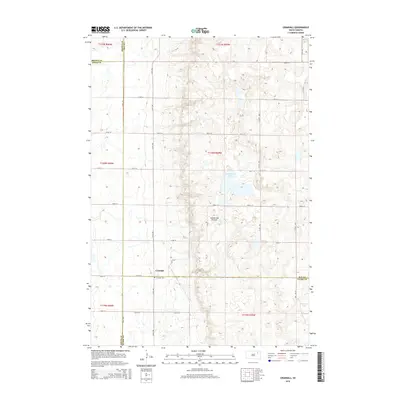
2015 Map of Crandall
USGS Topo · Published 2015About this map
The small settlement of Crandall serves as the focal point of this South Dakota landscape, situated at the intersection of 154th St and 413th Ave. This corner of the state is defined by the unique topography of the Coteau des Prairies, a high plateau that rises above the surrounding plains. The geography is marked by numerous prairie potholes and seasonal water bodies, with Sweetwater Lake and Lone Tree Lake providing distinct landmarks amidst the section-line road grid. For those tracing family histories in the region, the Crandall Cem is a significant genealogical site located just south of the primary townsite. The map also illustrates the meeting of four counties—Brown, Spink, Clark, and Day—highlighting the complex administrative boundaries of this rural agricultural area.
Find a feature on this map
30 named features on this map. Tap any name to fly to it.
Don’t see what you’re looking for? This feature index may not catch every label — zoom into the map to look around manually.
Map Details
Editions of this 2015 Crandall Map
This is the sole edition of this map. No revisions or reprints were ever made.
Other maps of this area

1894 · Conde
USGS Topo · 1:62,500

1895 · Aberdeen
USGS Topo · 1:125,000

1953 · Milbank
USGS Topo · 1:250,000

1954 · Ferney
USGS Topo · 1:24,000

1954 · Aberdeen
USGS Topo · 1:250,000

1956 · Aberdeen
USGS Topo · 1:250,000

1958 · Milbank
USGS Topo · 1:250,000
1958 · Conde
USGS Topo · 1:24,000

1958 · Andover SW
USGS Topo · 1:24,000
1958 · Crandall
USGS Topo · 1:24,000