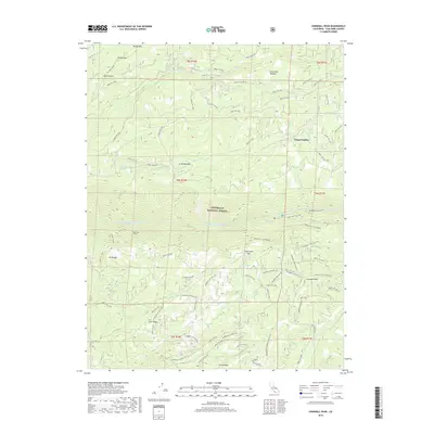
2018 Map of Crandall Peak
USGS Topo · Published 2018About this map
Stanislaus National Forest defines the character of this mountain landscape, where deep drainages like Middle Fork Stanislaus River and South Fork Stanislaus River carve through high ridgelines. The map reveals a complex history of infrastructure and recreation, specifically highlighting the Tunnel Cr. R/R Grade and the Stanislaus Tunnel near Mt Knight. These features suggest a legacy of industrial or water-management engineering within the canyon walls. High-elevation landmarks such as Crandall Peak and Schoettgen Pass oversee a network of forest routes and off-highway vehicle trails, including Crandall Pk OHV-M/C. Small outposts like Camp Pendola and Star Ridge are situated among numerous meadows and creek systems, such as Grohl Meadow and Griswold Cr, reflecting the region's long-standing use for both forestry and seasonal retreat.
Find a feature on this map
71 named features on this map. Tap any name to fly to it.
Don’t see what you’re looking for? This feature index may not catch every label — zoom into the map to look around manually.
Map Details
Editions of this 2018 Crandall Peak Map
This is the sole edition of this map. No revisions or reprints were ever made.
Other maps of this area

1891 · Big Trees
USGS Topo · 1:125,000

1894 · Big Trees
USGS Topo · 1:125,000

1897 · Big Trees
USGS Topo · 1:125,000

1901 · Big Trees
USGS Topo · 1:125,000

1947 · Sacramento
USGS Topo · 1:250,000

1948 · Sacramento
USGS Topo · 1:250,000

1948 · Columbia
USGS Topo · 1:62,500
1948 · Columbia SE
USGS Topo · 1:24,000

1948 · Stanislaus
USGS Topo · 1:24,000
1949 · Columbia SE
USGS Topo · 1:24,000