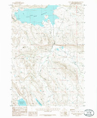
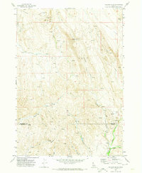
1986 Map of Crane Creek Reservoir
USGS Topo · Published 1986About this map
Crane Creek Reservoir dominates this landscape along the border of Washington and Gem counties in Idaho, as recorded in the mid-1980s. The topography is defined by the high relief of Tennison Ridge and the distinct peak of Ant Butte, which watch over a complex drainage system including Milk Creek and Tennison Creek. This area illustrates a mid-century water management strategy, with the larger reservoir to the north and the smaller Soulen Reservoir and Paddock Valley Reservoir to the south. The presence of several Borrow Pits and a Corral points to the local land use involving construction materials for these embankments and the livestock ranching that historically characterizes this high-desert terrain. These features together show a remote Idaho territory adapted for agricultural irrigation and cattle grazing.
Find a feature on this map
13 named features on this map. Tap any name to fly to it.
Don’t see what you’re looking for? This feature index may not catch every label — zoom into the map to look around manually.
Map Details
Editions of this 1986 Crane Creek Reservoir Map
This is the sole edition of this map. No revisions or reprints were ever made.
Other maps of this area

1894 · Squaw Creek
USGS Topo · 1:125,000

1897 · Weiser
USGS Topo · 1:125,000

1955 · Baker
USGS Topo · 1:250,000

1957 · Crane Creek Reservoir
USGS Topo · 1:62,500

1959 · Baker
USGS Topo · 1:250,000
1970 · Paddock Valley Reservoir
USGS Topo · 1:24,000
1970 · Coonrod Gulch
USGS Topo · 1:24,000

1970 · Granger Butte
USGS Topo · 1:24,000
1970 · Riley Butte
USGS Topo · 1:24,000
1970 · Holland Gulch
USGS Topo · 1:24,000