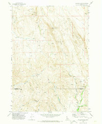
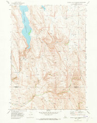
1970 Map of Holland Gulch
USGS Topo · Published 1974About this map
The Idaho Almaden Mine dominates the northern uplands of this landscape, accompanied by industrial markers including Mill Tailings and a Water Tank near the Stinking Water Basin. Surveyed in the early 1970s, the terrain is defined by a dense network of drainages and named gulches that cross the boundary between Washington and Payette counties. Significant topographic features like Wilburn Butte and the distinctively named Toe Jam Canyon punctuate the high ground, while the lower elevations are marked by seasonal watercourses like Toe Jam Creek and Little Willow Creek. The presence of a Corral near Wet Gulch and various Jeep Trails suggests a landscape utilized for both mining operations and ranching, characteristic of the remote Idaho interior during this era.
Find a feature on this map
23 named features on this map. Tap any name to fly to it.
Don’t see what you’re looking for? This feature index may not catch every label — zoom into the map to look around manually.
Map Details
Editions of this 1970 Holland Gulch Map
This is the sole edition of this map. No revisions or reprints were ever made.
Other maps of this area

1897 · Weiser
USGS Topo · 1:125,000

1952 · Weiser Cove
USGS Topo · 1:24,000
1952 · Birding Island
USGS Topo · 1:24,000

1953 · Mann Creek
USGS Topo · 1:62,500

1955 · Baker
USGS Topo · 1:250,000
1957 · Crane Creek Reservoir
USGS Topo · 1:62,500

1959 · Baker
USGS Topo · 1:250,000
1970 · Hog Cove Butte
USGS Topo · 1:24,000
1970 · Paddock Valley Reservoir
USGS Topo · 1:24,000
1970 · Sheep Ridge
USGS Topo · 1:24,000