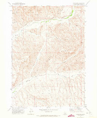
1970 Map of Sheep Ridge
USGS Topo · Published 1973About this map
The high, dissected plateau of Sheep Ridge dominates this 1970 landscape in Payette County, Idaho. The map reveals a highly specialized agricultural and water-management system defined by the Little Willow Creek and Big Willow Creek drainages. A network of man-made infrastructure, including a Canal, Flume, and Siphon, illustrates the effort required to move water through the complex terrain of gulches and canyons. Cattle ranching and land use are evidenced by landmarks like the Corral, several isolated Well locations, and a Storage Bin near the western edge. Notable family-named terrain features such as McIntyre Gulch, Clary Rose Gulch, and Patton Gulch provide important clues for genealogists and local historians tracking early settlement and land claims in the region. The map also documents numerous natural water sources including Bradford Spring and Sheep Spring, which were vital for sustaining life in this arid environment.
Find a feature on this map
27 named features on this map. Tap any name to fly to it.
Don’t see what you’re looking for? This feature index may not catch every label — zoom into the map to look around manually.
Map Details
Editions of this 1970 Sheep Ridge Map
This is the sole edition of this map. No revisions or reprints were ever made.
Other maps of this area

1897 · Weiser
USGS Topo · 1:125,000

1898 · Nampa
USGS Topo · 1:125,000

1952 · Weiser Cove
USGS Topo · 1:24,000

1952 · Birding Island
USGS Topo · 1:24,000

1955 · Baker
USGS Topo · 1:250,000

1955 · Boise
USGS Topo · 1:250,000

1958 · Boise
USGS Topo · 1:250,000

1959 · Baker
USGS Topo · 1:250,000

1962 · Boise
USGS Topo · 1:250,000
1965 · New Plymouth
USGS Topo · 1:24,000