
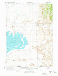
1960 Map of Crane
USGS Topo · Published 1962About this map
Malheur Lake and the eastern reaches of the Malheur National Wildlife Refuge define the hydrology of this high desert landscape during the early 1960s. The settlement of Crane serves as a local hub, situated at the junction of the Union Pacific railroad and a network of desert roads near the Crane Butte volcanic landmark. The geography is characterized by extensive sloughs, such as Ninemile Slough and Malheur Slough, which feed into the lake, creating a critical habitat for migratory birds centered around Pelican Island.
Find a feature on this map
36 named features on this map. Tap any name to fly to it.
Don’t see what you’re looking for? This feature index may not catch every label — zoom into the map to look around manually.
Map Details
Editions of this 1960 Crane Map
2 editions found
Other maps of this area

1955 · Burns
USGS Topo · 1:250,000

1958 · Burns
USGS Topo · 1:250,000

1959 · Burns
USGS Topo · 1:250,000

1959 · Harney
USGS Topo · 1:62,500

1959 · Lawen
USGS Topo · 1:62,500

1967 · Jackass Butte NE
USGS Topo · 1:24,000

1967 · Barton Lake
USGS Topo · 1:24,000

1967 · Adobe Flat
USGS Topo · 1:24,000

1968 · Venator
USGS Topo · 1:62,500

1972 · Circle Bar
USGS Topo · 1:24,000