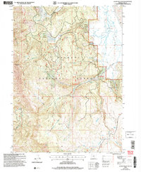
2004 Map of Crane Mountain
USGS Topo · Published 2007About this map
Crane Mountain and its high-elevation viewpoints anchor this segment of the Fremont National Forest, where the landscape transitions from sharp peaks into the broad drainage of Big Valley. The map highlights a network of remote recreation sites, including the Crane Mountain National Recreation Trail which traverses the ridge near Willow Point. Numerous headwaters originate here, with the Middle Fork and South Fork of Deep Creek carving through the terrain alongside Dismal Creek. Isolated forest camps like Willow Creek Forest Camp and Deep Creek Forest Camp provide specific locations for backcountry study. Smaller landmarks such as Mosquito Flat and Red Peak offer precise orientation for those researching land use and natural boundaries in this part of Lake County.
Find a feature on this map
32 named features on this map. Tap any name to fly to it.
Don’t see what you’re looking for? This feature index may not catch every label — zoom into the map to look around manually.
Map Details
Editions of this 2004 Crane Mountain Map
This is the sole edition of this map. No revisions or reprints were ever made.
Other maps of this area

1886 · Alturas
USGS Topo · 1:250,000

1892 · Alturas
USGS Topo · 1:250,000

1954 · Alturas
USGS Topo · 1:250,000

1955 · Klamath Falls
USGS Topo · 1:250,000

1958 · Alturas
USGS Topo · 1:250,000

1958 · Klamath Falls
USGS Topo · 1:250,000

1962 · Alturas
USGS Topo · 1:250,000

1962 · Willow Ranch
USGS Topo · 1:62,500

1962 · Fort Bidwell
USGS Topo · 1:62,500

1964 · Lakeview NE
USGS Topo · 1:24,000