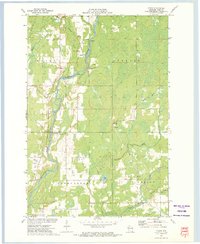
1972 Map of Crane
USGS Topo · Published 1975About this map
The Chippewa River and Flambeau River converge in this northern Wisconsin landscape, shaping the development of Rusk County's early settlements. Small communities like Murry and Imalone are documented alongside local landmarks such as St Anns Ch and the neighboring Cem. The map captures a moment of transition in rural transportation and industry, showing the functioning Soo Line rail alongside an Old RR Grade, marking the path of former timber or freight routes. Near the settlement of Crane (Flom Sta), the terrain is punctuated by numerous Gravel Pits and a Sandpit, reflecting the local extraction economy. Extensive marshlands and drainage networks, including Big Weirgor Creek and the Thornapple River, illustrate the hydraulic complexity of this glacial region as it appeared in the early 1970s.
Find a feature on this map
28 named features on this map. Tap any name to fly to it.
Don’t see what you’re looking for? This feature index may not catch every label — zoom into the map to look around manually.
Map Details
Editions of this 1972 Crane Map
This is the sole edition of this map. No revisions or reprints were ever made.
Other maps of this area

1944 · Exeland
USGS Topo · 1:48,000

1945 · Meteor
USGS Topo · 1:48,000

1947 · Exeland
USGS Topo · 1:48,000

1948 · Weyerhauser
USGS Topo · 1:48,000

1948 · Ladysmith
USGS Topo · 1:48,000

1949 · Meteor
USGS Topo · 1:48,000

1950 · Weyerhauser
USGS Topo · 1:48,000

1950 · Ladysmith
USGS Topo · 1:48,000

1953 · Rice Lake
USGS Topo · 1:250,000

1959 · Rice Lake
USGS Topo · 1:250,000