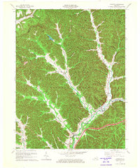
1970 Map of Cranston
USGS Topo · Published 1972About this map
Cranston and the surrounding woodlands of the Daniel Boone National Forest dominate this 1970 landscape, where the rugged topography of northeastern Kentucky is defined by a dense network of creek forks and hollows. The area's mid-century character is evident in the scattered small settlements and rural landmarks, such as the Hickory Flats Lookout Tower standing over the ridges and the Pumping Sta located along the pipelines that cut through the valley floor. Deeply integrated into the North Fork Triplett Creek valley, the community of New Hope and several country churches like Pine Grove Mission and Plank Ch reflect the area's local history. The convergence of the Lewis and Fleming county lines with the Rowan border highlights the political geography of these remote hills, where small-scale family landmarks like Evans Cem remain preserved within the forested terrain.
Find a feature on this map
27 named features on this map. Tap any name to fly to it.
Don’t see what you’re looking for? This feature index may not catch every label — zoom into the map to look around manually.
Map Details
Editions of this 1970 Cranston Map
This is the sole edition of this map. No revisions or reprints were ever made.
Other maps of this area

1929 · Morehead
USGS Topo · 1:48,000

1929 · Salt Lick
USGS Topo · 1:62,500

1934 · Salt Lick
USGS Topo · 1:62,500

1935 · Morehead
USGS Topo · 1:62,500

1950 · Head Of Grassy
USGS Topo · 1:24,000

1951 · Soldier
USGS Topo · 1:24,000

1951 · Cranston
USGS Topo · 1:24,000

1951 · Stricklett
USGS Topo · 1:24,000

1951 · Plummers Landing
USGS Topo · 1:24,000

1951 · Burtonville
USGS Topo · 1:24,000