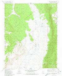
1981 Map of Crater Canyon
USGS Topo · Published 1981About this map
The Hualapai Indian Reservation defines the western landscape of this 1981 Coconino County study, where the plateau drops sharply into the expansive Aubrey Valley. The environment is characterized by its vital water management infrastructure, essential for ranching and survival in this arid territory. Man-made catchments like Jake McCain Tank, Trible Tank, and Crater Tank are scattered across the valley floor, alongside the Indian Well near Stonys Cabin. To the east, the dramatic Aubrey Cliffs rise as a formidable natural barrier, carved by the deep incision of Crater Canyon. Evidence of land use is found in several Gravel Pit and Borrow Pit sites, while old Corral placements suggest a history of seasonal grazing and livestock movement between the valley and the surrounding high country.
Find a feature on this map
18 named features on this map. Tap any name to fly to it.
Don’t see what you’re looking for? This feature index may not catch every label — zoom into the map to look around manually.
Map Details
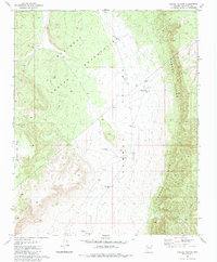
Editions of this 1981 Crater Canyon Map
2 editions found
Other maps of this area

1886 · Diamond Creek
USGS Topo · 1:250,000

1886 · Chino
USGS Topo · 1:250,000

1891 · Chino
USGS Topo · 1:250,000

1892 · Diamond Creek
USGS Topo · 1:250,000

1948 · Williams
USGS Topo · 1:250,000

1954 · Williams
USGS Topo · 1:250,000

1956 · Williams
USGS Topo · 1:250,000

1960 · Williams
USGS Topo · 1:250,000

1961 · Williams
USGS Topo · 1:250,000
1967 · Frazier Wells
USGS Topo · 1:24,000