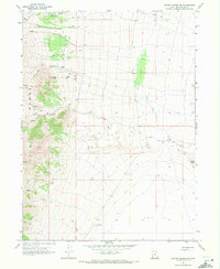
1967 Map of Crater Island NW
USGS Topo · Published 1972About this map
The Pilot Range dominates the western edge of this 1967 survey, where steep terrain gives way to the expansive Alkali Flat to the east. Water resources appear critical in this arid landscape, evidenced by the presence of an Aqueduct and multiple Tunnels in the northern sections, likely linked to livestock or mineral interests. The map documents several named water sources along the mountain slopes, including Patterson Pass Spring and McLaughlin Spring. Transportation is limited to a network of Jeep Trails that navigate the high ridges and deep cuts of Mc Ginty Canyon and Birch Canyon. This topographic study provides a clear view of the relationship between the elevated Mc Ginty Ridge and the low-lying basin floor near Lemay Island before modern developments altered these remote desert corridors.
Find a feature on this map
19 named features on this map. Tap any name to fly to it.
Don’t see what you’re looking for? This feature index may not catch every label — zoom into the map to look around manually.
Map Details
Editions of this 1967 Crater Island NW Map
This is the sole edition of this map. No revisions or reprints were ever made.
Other maps of this area

1954 · Brigham City
USGS Topo · 1:250,000

1955 · Wells
USGS Topo · 1:250,000

1958 · Wells
USGS Topo · 1:250,000

1958 · Brigham City
USGS Topo · 1:250,000

1961 · Wells
USGS Topo · 1:250,000

1962 · Brigham City
USGS Topo · 1:250,000

1967 · Pilot Peak
USGS Topo · 1:24,000

1967 · Pigeon Mountain
USGS Topo · 1:24,000

1967 · Lucin
USGS Topo · 1:24,000

1967 · Patterson Pass
USGS Topo · 1:24,000