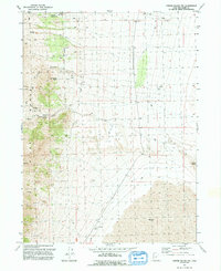
1991 Map of Crater Island NW
USGS Topo · Published 1992About this map
The eastern slopes of the Pilot Range define this high-desert landscape in Box Elder County, where essential water sources are meticulously documented. Numerous natural springs, including McLaughlin Spring, Birch Spring, and Patterson Pass Spring, emerge along the mountain flanks, while an Aqueduct and features like Tunnel Spring No 2 and Tunnel Spr No 1 show the infrastructure built to manage this scarce resource. To the east, the terrain transitions into the expansive salt flats of the Mud region, punctuated by the isolated landform of Lemay Island. Evidence of ranching or industrial activity is visible through labels for Storage Bins, a Water Tank, and a Well, all connected by a network of primitive 4WD tracks. The map captures a moment of transition between the steep geography of Mc Ginty Ridge and the featureless basin floor below.
Find a feature on this map
21 named features on this map. Tap any name to fly to it.
Don’t see what you’re looking for? This feature index may not catch every label — zoom into the map to look around manually.
Map Details
Editions of this 1991 Crater Island NW Map
This is the sole edition of this map. No revisions or reprints were ever made.
Other maps of this area

1954 · Brigham City
USGS Topo · 1:250,000

1955 · Wells
USGS Topo · 1:250,000

1958 · Wells
USGS Topo · 1:250,000

1958 · Brigham City
USGS Topo · 1:250,000

1961 · Wells
USGS Topo · 1:250,000

1962 · Brigham City
USGS Topo · 1:250,000

1967 · Pilot Peak
USGS Topo · 1:24,000

1967 · Pigeon Mountain
USGS Topo · 1:24,000

1967 · Lucin
USGS Topo · 1:24,000

1967 · Patterson Pass
USGS Topo · 1:24,000