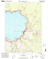
1999 Map of Crater Lake East
USGS Topo · Published 2002About this map
Crater Lake and its sheer volcanic rim define this landscape, as documented in this 1999 revision of the eastern caldera. The map details the intricate topography of the lake's edge, where the Cleetwood Cove Trail descends to the water's surface near the Boat Landing and Gaging Station. Further south, the dramatic island known as the Phantom Ship sits in Danger Bay, overshadowed by the towering Dutton Cliff.
Find a feature on this map
56 named features on this map. Tap any name to fly to it.
Don’t see what you’re looking for? This feature index may not catch every label — zoom into the map to look around manually.
Map Details
Editions of this 1999 Crater Lake East Map
This is the sole edition of this map. No revisions or reprints were ever made.
Other maps of this area

1889 · Klamath
USGS Topo · 1:250,000

1891 · Ashland
USGS Topo · 1:250,000

1893 · Ashland
USGS Topo · 1:250,000

1894 · Klamath
USGS Topo · 1:250,000

1897 · Ashland
USGS Topo · 1:250,000

1917 · Diamond Lake
USGS Topo · 1:125,000

1935 · Chemult
USGS Topo · 1:96,000

1941 · Chemult
USGS Topo · 1:125,000

1955 · Crescent
USGS Topo · 1:250,000

1955 · Klamath Falls
USGS Topo · 1:250,000