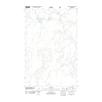
2011 Map of Crawfish Lake
USGS Topo · Published 2011About this map
Crawfish Lake serves as the focal point of this high-country landscape in Okanogan County, where recreational infrastructure and forest management roads define the human footprint. The map documents a network of primitive routes and forest service access points, including the Crawfish Lake Campground and the Stage Coach Trl. These pathways trace the drainages of the Lost Creek and Barnell Creek systems, which feed into open areas like Barnell Meadow and Lost Creek Meadow. This 2011 survey captures the area after decades of established forest service use, illustrating how Bureau of Indian Affairs (BIA) roads and county highways like County Hwy 3785 integrate with the natural hydrology of Swimptkin Creek and Clark Creek.
Find a feature on this map
21 named features on this map. Tap any name to fly to it.
Don’t see what you’re looking for? This feature index may not catch every label — zoom into the map to look around manually.
Map Details
Editions of this 2011 Crawfish Lake Map
This is the sole edition of this map. No revisions or reprints were ever made.
Other maps of this area

1902 · Osoyoos
USGS Topo · 1:125,000

1904 · Osoyoos
USGS Topo · 1:125,000

1952 · Disautel
USGS Topo · 1:62,500

1953 · Omak Lake
USGS Topo · 1:62,500

1954 · Okanogan
USGS Topo · 1:250,000

1957 · Tonasket
USGS Topo · 1:62,500

1957 · Aeneas Valley
USGS Topo · 1:62,500

1958 · Okanogan
USGS Topo · 1:250,000
1980 · Camp Seven
USGS Topo · 1:24,000
1980 · Omak Mountain
USGS Topo · 1:24,000