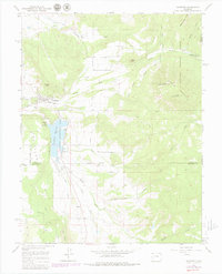
1965 Map of Crawford
USGS Topo · Published 1979About this map
Crawford serves as the central hub of this western Colorado landscape, situated just north of the expansive Crawford Reservoir. The town's agricultural foundations are evident in the complex irrigation network of the Clipper Ditch and View Siphon, which redirect water across the high mesas. To the east, the terrain rises sharply toward Saddle Mountain and the Gunnison National Forest, while distinctive volcanic landmarks like Needle Rock punctuate the Missouri Flats. South of the reservoir, the small settlement of Maher sits near the headwaters of Alkali Creek, marking the transition into the livestock-focused lands of Fruitland Mesa. This survey, compiled from 1964 photography and updated in the late 1970s, captures the region's reliance on water management through the Crawford Dam and numerous Gaging Stations along the Smith Fork.
Find a feature on this map
34 named features on this map. Tap any name to fly to it.
Don’t see what you’re looking for? This feature index may not catch every label — zoom into the map to look around manually.
Map Details
Editions of this 1965 Crawford Map
3 editions found
Other maps of this area

1938 · Mt. Gunnison
USGS Topo · 1:48,000

1945 · Mount Gunnison
USGS Topo · 1:62,500

1956 · Montrose
USGS Topo · 1:250,000

1957 · Cathedral Peak
USGS Topo · 1:24,000

1957 · X Lazy F Ranch
USGS Topo · 1:24,000

1957 · Grizzly Ridge
USGS Topo · 1:24,000

1959 · Montrose
USGS Topo · 1:250,000

1960 · Montrose
USGS Topo · 1:250,000

1964 · Minnesota Pass
USGS Topo · 1:24,000

1965 · Mount Guero
USGS Topo · 1:24,000