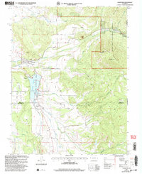
2001 Map of Crawford
USGS Topo · Published 2004About this map
Crawford serves as the focal point of this Delta County landscape, situated at the intersection of a complex irrigation network and the high alpine terrain of the Gunnison National Forest. The 2001 revision illustrates the local reliance on water engineering, featuring the Crawford Reservoir, the Clipper Ditch, and the Grand View Canyon Siphon which support the agricultural expanses of Fruitland Mesa and Missouri Flats. To the east, the topography rises sharply toward the volcanic prominence of Needle Rock and the dual peaks of Saddle Mountain. Settlement patterns are concentrated around the town and south toward Maher, with local landmarks like the Cem and Gaging Sta providing specific points of interest for genealogical and hydrological research. The confluence of Iron Creek, Alkali Creek, and Muddy Creek creates a dramatic series of drainages, including the deep Iron Canyon, that define the southern portion of the quadrangle.
Find a feature on this map
40 named features on this map. Tap any name to fly to it.
Don’t see what you’re looking for? This feature index may not catch every label — zoom into the map to look around manually.
Map Details
Editions of this 2001 Crawford Map
2 editions found
Other maps of this area

1938 · Mt. Gunnison
USGS Topo · 1:48,000

1945 · Mount Gunnison
USGS Topo · 1:62,500

1956 · Montrose
USGS Topo · 1:250,000

1957 · Cathedral Peak
USGS Topo · 1:24,000

1957 · X Lazy F Ranch
USGS Topo · 1:24,000

1957 · Grizzly Ridge
USGS Topo · 1:24,000

1959 · Montrose
USGS Topo · 1:250,000

1960 · Montrose
USGS Topo · 1:250,000

1964 · Minnesota Pass
USGS Topo · 1:24,000

1965 · Mount Guero
USGS Topo · 1:24,000