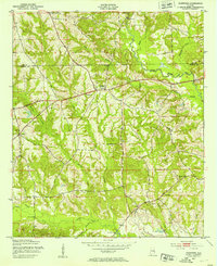
1950 Map of Crawford
USGS Topo · Published 1953About this map
Crawford serves as a central hub in this mid-century topographic study, situated where the boundary between Lee County and Russell County meets a landscape defined by rolling drainages. The area is characterized by a dense network of rural infrastructure, notably the small community churches and schools that anchored East Alabama life during this era. Trace the paths of St Pauls Ch, St Johns Ch, and Uchee Chapel, alongside the Uchee Sch, which highlight the social centers of the rural population. The terrain is deeply carved by waterways like Little Uchee Creek and Maringo Creek, with numerous crossings such as Mott Bridge and Bishop Bridge facilitating movement along routes like Sandfort Road. This 1950s documentation provides a clear view of the transition from traditional agricultural patterns to the established road networks of the modern era.
Find a feature on this map
25 named features on this map. Tap any name to fly to it.
Don’t see what you’re looking for? This feature index may not catch every label — zoom into the map to look around manually.
Map Details
Editions of this 1950 Crawford Map
2 editions found
Other maps of this area

1907 · Opelika
USGS Topo · 1:125,000

1909 · Opelika
USGS Topo · 1:125,000

1914 · Seale
USGS Topo · 1:62,500

1949 · Fort Mitchell
USGS Topo · 1:24,000

1950 · Crawford
USGS Topo · 1:24,000

1950 · Seale
USGS Topo · 1:24,000

1950 · Phenix City
USGS Topo · 1:24,000

1950 · Seale
USGS Topo · 1:62,500

1955 · Phenix City
USGS Topo · 1:24,000

1955 · Seale
USGS Topo · 1:24,000